I have spent a good deal of time over the past 17 years playing around in southern Utah. It has always been either right after the busy ski season in the spring months or directly before it in the fall. If I was in the neighborhood (within 300 miles of Moab lets say) I would make it a point to get over that way. Western Utah though, specifically central and north though has been a big ? on my map. A place devoid of many roads, towns, and development, it has been calling my name for awhile.
We decided to do another one of those 2 and a half day weekends. Using the trusty Utah Road and Recreation Atlas along with some great suggestions from folks in the know I put together what looked to be a pretty promising route. The majority of it would be nice, graded dirt roads that passed areas of interest we could explore. The original plan was to follow the Pony Express Trail but it was recomended to try the Weiss Highway a bit further south for the main leg west.
With the car loaded we hit the road from Salt Lake City in the afternoon on Friday. We took I15 south till we hit highway 6 in Santaquin which would take us in a westerly direction to the Little Sahara. Little Sahara is an incredibly popular BLM special uses area featuring huge sand dunes and tons of folks dragging atv’s, bikes, and motorized contraptions to feed their cravings. Being a Friday there were alot of big toy haulers rolling in there. We were hoping to get away from people so with no haste we worked our way across of series of dirt roads that would take us out far away from the people and get us some nice, welcomed solitude. A contrail of dust rolled off the back of the car as the shadows got longer.

We spotted antelope close to the road who were our welcoming comittee to the neighborhood.

Eventually we found a great, random spot to pull off against a cluster of rocks that are part of the small Desert Mountain chain. Its basically an island of rocks in a sea of dry grasslands. We popped open the tent and got busy making a quick dinner. While its nice to make fresh food while out, essentially car camping, we find on these late day departures that an easy meal the first night makes things much easier. So heating up some bagged Indian food with rice and we were relaxing with some good food watching the twilight in no time.
With no moon in the sky the stars were brilliant. Temperatures dropped a bit but so far it was the warmest evening of camping we had had yet this spring. Since we were both pretty pooped we crashed out pretty quick.

I have this strange obsession where I feel compelled to get out of a cozy bed, regardless of the weather, season, etc and catch the sunrise when I am camping. I am not a photographer, heck I don’t even own a camera so I can’t use that as an excuse. Alyssa does not seem to share my exuberant enthusiasm for these pre dawn escapades and seem completely content to slumber…. I often feel a tinge of jealousy over this talent. She had a busy work week so this was what she was looking forward too. I on the other hand am basically on vacation this month so I am chomping at the bit to get out of the city. I found a nice perch on some rocks behind the camp and watched the shadows race across the valley as the sun bathed the grasses in brilliant bright light. Today would be warm one.

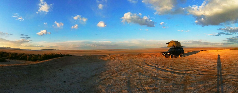
View from the top of the ridge above camp. We scrambled up and took in an amazing panorama of the landscape. Pictures don’t begin to capture the feeling of a landscape of such broad scale.

Our house on wheels.

Fun with Pano

Rolling out. Todays route would be entirely dirt untill we closed in on the Nevada border. Looking at the map, there wasn’t much in the way of development out there and that to us was the allure. Having a fresh set of light truck all terrain tires on the Subie definately gave some piece of mind with regards to worry about flats on the endless miles of dirt/gravel roads.

There was certainly no shortage of snakes sunning themselves on the road.

One of those roads to nowhere pictures.
Our next stop would be the Topaz Mountain rock hounding area, as labeled on the map. We didn’t really know what a rock hounding area was, but it sounded interesting. As we approched this area we started seeing campers, cars, cub scouts…. turns out rock hounding is quite a big deal! A paved road from Delta runs near this point and provides easy access to folks. We were surprised at just how many people were camped out around Topaz Valley. We pulled off and scurried up a ridge, not sure what we were supposed to be hounding, or looking for.

While no valuable stones would be found, we did get some fresh air, a bit of sun and a view of the area. We learned later that with proper tools like a shovel and hammer folks find geodes here. Next time we will come better prepared.
After getting back in the car we continued accross the Weiss Highway. After leaving Topaz Mtn we wouldn’t see another soul for 100 miles! The landscape was stunning. Valley after valley, vista after vista of absolutely enormous views of mountain chains extending in a north south direction with dry, brushy, flat floored valleys in between. While this sounds harsh, perhaps barren and ugly, it couldn’t be farther from the truth. Each mountain seemingly was bathed in different color rocks, if fact there were rich colors everwhere, all contrasting with a bright blue, clear sky. I see why some folks become so enamored with the desert. Being a water guy I feel a bit out of my element still but I enjoy it nonetheless.

We pulled off at a place called the Honey Combs. To the west the Deep Creek Range stood with snow capped peaks over 12,000 feet high. To north the south edge of the Great Salt Lake Desert was visible. This is essentially the southern edge of the salt flats. A huge expanse of land mostly closed off to public and designated milatary land used for bases and training ranges. We drove up a two track a ways and found a nice spot with some shade near an old mine and had lunch.

This is the entrance to the old mine shaft next to where we pulled off.

A view to the north with the salt flats visible.

After continuing on we turned north to intercept the Pony Express Trail. It essentially follows the south end of the salt flats in this portion of Utah. The Pony Express Trail is a scenic backcountry byway now with signs making it easy to follow. The point where we merged with the trail was at the Willow Springs Station which is a settlement known as Callao. Calloa has current residents, most of whom live in original old chinked log farmsteads. With a spring there and freshwater it is quite literally an oasis in the desert complete with giant cottownwood trees and irrigated fields. Interesting spot, these folks can’t just zip into town for supplies easily as Wendover is over 70 miles away, the majority of it on dirt roads.

A shot of one of the old structures in Callao.

We now followed along the Pony Express trail, skirting the edge of the salt flats and working our way up to Overland Canyon, a very apporopriate name for this outing, and over the range of mountains to the west. At the base of the canyon stands this spot which was another Pony Express station. What is interesting to note is that every 8 to 10 miles the Pony Express needed a station to change off horses at. A galloping horse could only sustain that kind of distance before needing to rest. Each station was manned by a person who tended the horses. These folks were quite alone outside of fairly frequent attack from natives. The salt flats can be seen here in the background more clearly.

Alyssa stretching her legs and checking out the remains of the station here. The only other person we saw since we left Topaz mountain, around 100 miles ago, was a guy on a KLR 650 (dual sport bike) here. I couldn’t help but to feel a bit jeaous, despite how comfortable the Outback was, the idea of riding across this on a bike sure sounded like pure freedom. After another half hour continuing west we came out on blacktop and followed it due north to Wendover a town that straddles the Utah/Nevada border. We gassed up here before heading off on the second portion of the trip. We had just logged 150 miles of dirt roads alone getting to this point.

Wendover lies on the western edge of the salt flats, I80 crosses them from the east. On the outskirts of town lies the famous Bonneville Salt Flats. The site where numerous world land speed records have been smashed from anything with jet powered cars exceeding 600mph to a guy in his underwear laying across the top of his Indian Motorcycle. Its the ultimate mecca for speed freaks. Being an admittant car dork of the highest order its a place that I love to visit. Bonneville Motor Speedway sounds pretty impressive, what do you picture? The reality is that it is simply the end of a short 4 mile stretch of blacktop that deposits you out onto the good dry salt. This is the where the famous imaginary 12 mile long straight line in the salt of the Bonneville Speedway is. No grandstands, hot dog vendors, actually nothing other than a sign posted at the end of the road. The best time of year to drive on the salt flats is summer through fall, thats when it is dryest. Spring can be iffy with soft conditions that many an adventurous driver has found himself stuck in. Not a place to drive off and get stuck, especially with the intense sun beating down on you…. and up at you. It reflects off the salt surface giving the feeling of seemingly being cooked from below and above at the same time. Where your sunscreen! Despite the salt being a little damp we drove out a mile or so to snap some pictures. If you veer left much from this imaginary straight line, especially near the beginning, things tend to get soggier, so knowing this we were quite careful of where we went.

Again, photos can’t capture the scale of the salt flats.

Our goal for the evening was to get to the north end of the Silver Island Mountains. They are named this since they are literally islands of land in the midst of this salt flat basin. In prehistoric times they actually were islands in Lake Bonneville which now is reduced to the Great Salt Lake. Anywhere in the old Lake Bonneville basin you can see the old bath tub ring of shoreline of where the lake level once was quite high up in the base of the mountains here and around the Salt Lake City side as well.

Circling around the Silver Island Mountains is another scenic designated backcountry byway. A graded dirt road, incredibly dusty, but with great views of the mountains as it follows along the edge of the salt flats.

Looking out across the flats to Floating Island.
We contiuned on till we reached the Donner-Reed pass which crosses a small ridge on the north end of the mountains. It was here that the ill-fated Donner party crossed the salt basin on its way to destiny in the California Sierras. The Donner party had lost time battling mud and heat crossing the salt flats and made a northerly detour here to reach a spring on the far side of the basin. This route is now marked as the California National Historic Trail and crosses this point. We found a nice place up off the dirt road a ways on an overgrown two track that is the actual California Trail. We wanted a spot where we could catch both the sunrise and sunset. This was perfect. It was a calm evening. We set up camp and relaxed a bit. We were both a bit drained from sun exposure.

I had remounted the roof top tent since the last outing so that it opens off of the side of the Subaru allowing the ability to set up the lower tent as well as open the back hatch completely. Much better. Even when the weather is warm, there is still always the trouble of getting winds blowing creating conditions that make cooking dinner challenging. Having the lower enclosure is perfect for getting out of the wind, rain, sun, snow, etc and have a place to cook. Fortunately for us, it stayed calm all evening and we were able to prepare dinner under the open sky, the best way.

Alyssa cooking up some grub while I get my Ansel Adams on…..


And the finished product. Nothing says evening in the desert then some fresh Mexican food.

The sun sets behind the Pilot Range.

Winding down the evening at camp.
We sat out and watched the stars wash over the sky. I caught the glimpse of a meteorite starting off slowly. I had time to tell Alyssa to look up from what she was doing. We watched it pick up speed and cross the entire sky leaving a trail. It was huge. I saw a few other small ones too. Little did we know but it was a meteor shower that night. The following morning a piece of space rock would break up over Reno, Nevada and shake windows with a giant boom. An owl in the hills nearby serenaded us to bed. It was the first evening of the year we had the flaps up on the RTT and slept comfortably with the sounds of the desert and a gentle breeze blowing through the tent. It was the best night of sleep I have had in some time.
We awoke to the sound of a pack of coyotes yipping and howling. We had made note the night before of coyote scat along the trail near our camp. We figure this pack regularly used the trail as a highway for their travels and they were surprised/annoyed by our tresspass.
We had a leisurely morning, laying in bed, making breakfast, and procrastinating packing up. It was Sunday, our last day out. Fittingly it was also Earth Day and we were surrounded by stunning landscape and had alot of things still to see today on our route. We would continue around the loop of the Silver Island Mountains then connect with a dirt road that travels north to the old Transcontinental Rail Line. We would then follow that east to Promontory Point, the site of the Golden Spike.
One thing that is so nice about having two people camping together versus going solo is the speed and efficiency of packing up and getting underway. Solo, with the whole campe setup it could take me up to 45 minutes to break everything down and put it away. The key to living day in and day out of a vehicle comes from good organization. If you just throw everything in the car it creates total chaos. Dirty undies laying on the food bag, can’t find something when you need it, not good, not good. So taking a few extra minutes and packing right saves time and frustration later. We got the packed up in an easy 15 minutes and were off. It was supposed to be the hottest day yet with temps touching 90 degrees. We were both a bit red from the sun on Saturday and despite drinking tons of water, a bit dehydrated too. Its amazing how much fluids your body looses in these conditions and we weren’t really even doing anything that strenuous!

Again, more snakes on the road.

Stopping to check out some cool rock formations.


Despite her clear wishes, I manage another shot of Alyssa. Great view of the dry lake bed behind. We end up taking a short cut across that and it gets interesting.

On the map we see a road that short cuts straight across the south end of the dry lake/akali flat. Its a dead straight shot following a water aquaduct that must feed into Wendover.

It wasn’t well travelled, and by the time you were half way across it was just a barren, dry lake bed. Ugh, which way??

As we got closer to the other side the surface changed from dry, cracked mud to damper and damper surfaces. The trail virtually dissapears and it is getting wetter yet. Mud beds tend to form near the outlying edges of dry lakes and are notorious for luring people over them in trucks and letting them sink to the axles. We tryed several attempts to drive around the wet area by circling out farther from the route on the dry lake bed to no avail. We end up stopping and get out to walk the area a bit to figure out the next course of action. Doubling back would add alot of time and miles and with the amount of driving we had to do today before we got to fuel, the idea of adding mileage wasn’t appealing. After trampling around a bit I see a fairly recent set of truck tires cross a particularly wet looking area to dry ground. The tracks didn’t sink into the soil must and judging by the width of the tracks I would gues it was a full size truck, thus much heavier than the Subaru, this is good news. I end up following the tracks, but with a bit of extra momentum for safe measure. We crossed the wet area with no issue other than a fresh coat of some nasty mud that dried onto the car like concrete. Soon we intercepted the dirt road known as TL Bar Ranch Rd. Its the only road this side of the salt flats and runs north south.

A view looking south over the Great Salt Lake Desert. The small mountains in the center and background of the image are the Silver Island Mountains were we camped the previous night.
We stopped for lunch under the shade of some trees, large cottonwoods in fact at the old rail station site of Lucin. Nothing remains of Lucin other than the spring, the trees and a sign. After not seeing any trees all day, it was nice to have lunch under the trees with a comfortable breeze blowing. We had missed a turn off for the Sun Tunnels a couple of miles back but would backtrack after lunch.

Some weather building to the west.

View out of one of the sun tunnels. The sun tunnels are artwork created by Nancy Holt, built in 1976 consisting of four concrete tubes placed in an x pattern in the middle of virtually nowhere. The tunnels are set so that they line up with the sunrise and sunset at both the summer and winter solstices. They also have holes drilled in them that align with certain constellations. Pretty random but it was a cool to check them out.

After the Sun Tunnel visit we headed back up to Lucin and connected with the old Transcontinental Rail Line. It is here that the old rail line separates from the current line that crosses the Great Salt Lake and the salt flats. The old line is now a narrow dirt road crossing a landscape that has been virtually unchanged from the time they built the line, even back 10,000 years before it.

From Lucin it will be 100 miles across this desert and grassland landscape till we see Promontary Point. It starts to sink in at the sheer scale of the project to connect this nation that these people undertook, mostly with hand tools. We cruise along the old raised grade comfortable at 45mph in air conditioned comfort. Just like the previous evening’s campsite, on a crucial part of the California trail where the Donner party was strugalling in the heat and suffering dehydration and exposure. We are out visiting these inhospitable places with the comfort of a bed with a mattress, perishable foods and drinks cooled on ice. Covering amounts of ground not even considered in the pioneers’ wildest dreams. They were trying to conquer, survive, and cross what we were just out in it for recreation. We have the technology now to see all of this, do these things, yet so few do. So few escape the confines of the cities, suburbs, and neighborhoods where they reside. There lives are spent between climate controlled homes, cars, and work places. It suddenly seems so absurd to me that more people don’t get out of the artificial world that we have created and reside in, and see the real world more often. This point was driven home by the fact that we had only passed one truck yet today, back on the previous road, and wouldn’t see another vehicle till close to Promontary Point. I guess I should be thankful because it is the places like these with no one around that I enjoy the most.
The drive along the old grade is frequently broken up by small detours around old trestles that are not fit for travel. Other than that the first portion is arrow straight.

An old trestle along the line.

We stopped at the site of the Terrace, once a stop for the rail line. Now all that is left are some mounds where the foundations used to be and a forlorn cemetary. A lizard poses on a tombstone for effect.

Another image that conjures up the ghosts of the past.
We were swallowing up miles again and started climbing in elevation throught the hilly lands north of the Great Salt Lake. We were approaching the Promontory Mountains, a section that was difficult to build and for the trains to travel. It was this challenging section that eventually led to the bypass and modern rail line saving 36 hours of time for the trains passing through.

We finally reached Promontory Point, this is the exact spot where the Golden Spike was driven and thus connection the US for the first time. Travel that took 6 months to cross the country now took 6 days. It was a major step in making our world as we know it much smaller in a sense. Today the National Park Service has a visitor center there with great displays and the history of the rail line.
At this point we hit pavement again for the first time since Wendover. We had travelled 208 miles via dirt. We took pavement to Brigham City where we caught I15 and headed back south for Salt Lake. The car was filthy. Actually thats an understatement. We drove most of the trip with the windows down and wind blowing. This seemingly allowed fine dust to be pulled in through the back hatch seals and cover the entire interior of the car in a fine white layer of dust. Silt would be a more accurate description really.
In the end the car worked perfectly. We covered 358 miles of dirt roads, some rough, some smooth (not counting any pavement driving in the beginning or end) and explored two tracks as well. We averaged 22mpg and had great comfort. I would imagine the ride over those same washboard surfaces to be tiring in a truck like my Land Cruiser but the beauty of independent suspension is the ability to drive over rough surfaces fast and comfortably. Truth be told, we covered that whole route and never once did I feel we couldn’t explore anything we wanted to see due to not having a real 4wd. On top of that, a fast turbocharged car is much more fun to drive too on these roads. The car did amazing and was no worse for the wear. So far this experiment has been pretty favorable for going light overland. Stay tuned, more to come as we look forward to more southern Utah outings as well as Overland Expo in May.

Wow. This looks awesome! Great photos, and incredibly detailed posting. I approve 🙂
I’ve never camped quite like this before. I’m going to have to give it a try.
Great photos, would love to explore one day.
Awesome first post Kristian, way to go! You saw lots of cool stuff in that Subi.
Thanks for posting this – I will have to check this out sometime.